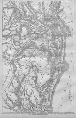
CIVIL War Map Of Charleston Plantations Inlets Roads 1863 Fort Sumter Moultrie


Antique Engravings, Prints, Maps and Newspapers sells only original/authentic material. Museums, Historical Societies, Universities, Educators, Movie sets. CIVIL WAR MAP OF CHARLESTON PLANTATIONS INLETS ROADS. This genuine antique map is titled MAP OF CHARLESTON, S. SHOWING THE APPROACHES BY LAND AND WATER, THE REBEL BATTERIES AND LINES OF FIRE, ROADS, INLETS, PRINCIPAL PLANTATIONS, ETC.
COMPILED FROM VARIOUS SOURCES", published in "Harper's Weekly March 1863. This dated map from the year of 1863 is 11 x 15 inches in size with wide margins. It is in excellent condition, highly displayable and ready for framing and is guaranteed to be as described. The lines you may see in some of the older WOOD-CUT maps are from the adjoining of woodblocks to make/produce the complete image.
In order to speed up the process of wood-cut engravings and maps, several artists carved a section of the block of wood then the blocks were adjoined, stamped in ink then onto this page. Also occasional spots or foxing are usual for these older maps. They do not detract from the value or splendor of the engraving but only attest to it's authenticity! This beautiful and decorative antique map would make a great addition to any Home, Office or Restaurant decor! I have provided Antique Engravings, Prints, Maps & Newspapers globally to museums, Institutions, art dealers, researchers, genealogists, movie sets, interior designers, curators, authors, knowledgeable collectors and beginners too. The comments buyers have made in my "feedback" file are an indication of the quality product and exceptional service I deliver. Authenticity of all items, as described in each listing, and the accuracy of that description, is guaranteed unconditionally. At your fingertips here at this website you have a gallery of many thousands of Antique Engravings, Prints, Maps and Newspapers. Find the subject matter you are looking for using my Store Search engine provided. Every item I sell is genuine/original, NOT reproductions and guaranteed to be as described.Thank you very much for taking the time to stop in and look at these remarkably well preserved historical relics of the past! About ENGRAVINGS PRINTS MAPS NEWSPAPERS. Add our store to your favorites to receive newsletters about new items & special promotions! Thank you For visiting our Store. The item "CIVIL WAR MAP OF CHARLESTON PLANTATIONS INLETS ROADS 1863 FORT SUMTER MOULTRIE" is in sale since Friday, January 22, 2010.
This item is in the category "Collectibles\Militaria\Civil War (1861-65)\Original Period Items\Maps & Atlases". The seller is "nls" and is located in New London, Minnesota. This item can be shipped worldwide.- Country/Region of Manufacture: United States

