Original Antique Civil War CHARLESTON South Carolina SC Engraved Panoramic Map


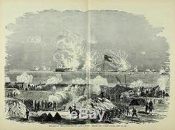
Fine Adornment of Civil War History. Impressive on any Home or Office Wall. The Federal Fleet in Charleston Harbor Firing on Fort Sumter The Federal Fleet, Commanded by Admiral Dupont, Opening Fire on Fort Sumter. Engraved From Sketch by F. Engraving is in Very Good/Good condition.
Huge 16"x21.5" Engraving. Illustrating the Valor of the Soldier as Displayed on the Battlefield. From Sketches Drawn by Forbes, Waud, Taylor, Hall, Becker, Lovie, Shell, and Crane; Paul F. Mottelay, Editor; With an Introduction by Robert B. Breath, Past Commander-in-Chief Grand Army of the Republic; Including a History by Paul Vandervoort, Past Commander-in-Chief; and a History of the Sons of Veterans by A.Merrill; Published 1884 by J. Brown Publishing Company: New York, 1884; a copy of the Title Page of which is Included. Impressive On Any Home or Office Wall Dimensions: 16"x21.5" Fine Adornment of Civil War History.
Large: 16"x21.5" A Stunning Addition to any Civil War or American History Collection. Greetings from Historical Savannah, Georgia: Founded 1733. Some, to beautify their halls, chambers, & studies... Loveth, getteth, and useth maps, charts, and geographical globes. John Dee, Advisor to Queen Elizabeth I.The item "Original Antique Civil War CHARLESTON South Carolina SC Engraved Panoramic Map" is in sale since Friday, July 20, 2018. This item is in the category "Antiques\Maps, Atlases & Globes\North America Maps". The seller is "jonesjackson" and is located in Savannah, Georgia.
This item can be shipped worldwide.- Type: Civil War Map
- Maker: J. Brown
- Original/Reproduction: Antique Original
- Continent: North America
- Country/Region: United States of America
- North America States & Provinces: South Carolina
- Year: 1884
- Printing Technique: Woodcut
- Era: 1800s
- Map View: Panoramic
- Format: Engraving
- Date Range: 1800-1899
- Cartographer/Publisher: J. Brown
- City: Charleston
- US State: AL, FL, GA, MS, NC, SC

